Showing posts with label Maps. Show all posts

Sunday, November 06, 2022

"OLEIDA"


OLEIDA is an acronym for the Ohio Lake Erie Island District Association, which was an organization that promoted tourism in the north central portion of Ohio, later known as “Vacationland.” In July of 1931, uniformed Boy Scouts passed out OLEIDA booklets and area maps at the southeast and northwest corners of Wayne and East Washington Streets.

An advertisement in the July 3, 1930 issue of the Sandusky Star Journal stated that the Lake Shore Electric Railway was the direct line to “Oleida.”


The Sandusky Star Journal of July 11, 1931 announced that Put in Bay would be celebrating “Oleida Day” on July 14, during the Interlake Regatta.


In the winter of 1932-1933, Sandusky area merchants sponsored a contest in which young ladies in Sandusky could win a trip to Bermuda, while ladies from the region outside Sandusky could win a trip to New York and Washington D.C. For every dollar spent at each merchant, 100 votes would be cast for the lady of your choice. The Sandusky Register of January 18, 1933 reported that Alice Mix was chosen as “Miss Oleida” and Mildred Cullen had won the title of “Miss Sandusky.”


During the Depression years of the 1930s, Sandusky area residents’ days were brightened by the promotional activities of the Ohio Lake Erie District Association, and visitors from other parts of the state and country were introduced to the joys of fishing, boating, and other activities found in the north central part of Ohio.

Tuesday, July 20, 2021

Paul F. Laning, Teacher and Railroad Historian


Paul F. Laning was a teacher at Sandusky High School for thirty years. He had previously worked for the Nickle Plate Railroad and taught at Kirtland, Ohio for five years. After retiring from Sandusky High School in 1968, he served as bailiff in the Erie County Court of Common Pleas for six years. Though Mr. Laning had been the head of Sandusky High’s English department, he was extremely interested in history, particularly the history of railroads. His Master’s Thesis at Ohio State University was: The History of the Lake Shore and Michigan Southern Railway in Ohio. 

Mr. Laning was a popular guest speaker for area clubs and organizations. In 1953 he unearthed an original account of the May 1838 trip of David Campbell, founder of the Sandusky Clarion newspaper, on the Mad River and Lake Erie Railroad, to and from Bellevue, Ohio. Campbell was amazed that the return mile trip of fifteen miles from Bellevue to Sandusky took only forty five minutes by rail (about 20 miles per hour). This story of the first commercial trip of the Mad River and Lake Erie Railroad appeared in the June 19, 1953 issue of the Sandusky Register Star News.

Featured in the Twin Anniversary Edition of the Sandusky Register and Star News, November 24, 1947, is an article about the History of Steam Railroads in Erie County, written by Mr. Laning.


He wrote that Eleutheros Cooke and other Sandusky leaders had been quite upset over Cleveland becoming the northern terminal of the Ohio and Erie Canal instead of Sandusky, but these civic leaders felt that Sandusky being chosen as a terminus for the the Mad River and Lake Erie Railroad compensated for the loss of the canal. General William Henry Harrison broke ground for the railroad at the corner of Water and Meigs Streets on September 17, 1835.

The sketch map below, drawn by Mr. Laning, shows Sandusky’s Railroads and competing routes in 1854.

A rough draft of a speech Mr. Laning gave, entitled Sandusky and Cleveland: Railroad Rivals in the 1850s, is on file in the Transportation Collections of the Sandusky Library Archives Research Center. Mr. Laning had a deep understanding of the history of Ohio Railroads, and he enjoyed sharing his knowledge with others.

Paul F. Laning died at the age on 90 on August 30, 1991. He had been a charter member and president of the Erie County Historical Society. He was also a member of the Firelands Historical Society, Ohio Historical Society, Mad River and Nickle Plate Railway Society, Erie County and Ohio Retired Teachers Associations and the Senior Men’s Fellowship Club of the YMCA.

Friday, November 20, 2020

1932 Map of the City of Sandusky

This map of Sandusky from 1932 was featured in an Erie County Directory.


An ad for the former Caswell Auto and Machine Co., which was located on Jackson Street, advertises service to R.C.A. radios, besides storing and repairing automobiles and selling oil, gasoline, and other supplies. Individual names of railroads are labeled on the map, including the B & O, New York Central, Lake Erie & Western, and the C.C. C. and St. Louis Railroad.

There is not yet a golf course near Mills Creek, but the Woodlawn Golf Course is shown between Old Railroad and Hayes Avenue, just south of Perkins Avenue. St. Mary’s and St. Joseph’s Cemeteries, found on opposite sides of Mills Street, are called the “German Cemetery” and the “Irish Cemetery,” though certainly people of many different ethnic backgrounds were buried in each.

There are no Perkins or Sandusky Plazas in 1932, and the map contains considerably fewer streets than a current map of the city. A few streets that still exist had different names in the 1930s, e.g., 52nd Street was called Austin Street, and Huntington Street was also known as Roosevelt Street.

Pictured below is a photograph from the Woodlawn Golf Course, which opened in 1931. The golf course only lasted about a year, due to financial difficulties. Mel Carrier was the golf pro (third person on the right). An old ad offered customers the opportunity to “play on velvet greens.”

Pictured below are: John Rheinegger, owner, Boyd Hamrick, and Chester Bohn, greenskeeper.

Monday, February 26, 2018

Map of Sandusky, Circa 1915


This map of Sandusky was printed about 1915, through the courtesy of the American Banking and Trust Company in Sandusky, Ohio. An ad attached to the map was sponsored by F.A. Purdy, who was the manager of the Sandusky Buick Company at that time.


The words “Proposed Park” appear at the site of what we now know as Battery Park. An article in the June 16, 1914 issue of the Sandusky Register reported that two thousands loads of dirt had recently been taken over to the proposed park area as fill. Plans were in place for shade trees to be planted in 1915. Sandusky City Service Director J.J. Molter stated that Battery Park would one day be a “beauty spot” of the city. This 1956 aerial view of Battery Park shows the layout of the park along Sandusky Bay.


In the 1915 map, there were docks along the waterfront for the Cleveland, Cincinnati, Chicago and St. Louis Railway, the Pennsylvania Railroad, Cedar Point, and the B and O Railroad. The old water works was still standing on Meigs Street, approximately where Sandusky’s municipal building is now. The areas between Fifth Street and Cleveland Rd., as well as between Cleveland Road and Milan Road were relatively undeveloped at this time. This postcard from the Perry Centennial in 1913 provides us with a festive view of Columbus Avenue in Sandusky a couple years before the map was printed.


Thursday, June 15, 2017

The Stone House on East Perkins Avenue


The old stone house at 1338 East Perkins Avenue has a very rich and interesting history. An undated paper in the historical files at the Sandusky Library Archives Research Center provides many details about this structure. In Sheila Gockstetter's paper, “The Stone House: Ever a Refuge,” the author explains that Aaron Whipple and his nephew Allen Remington designed and built this limestone home around the shell of a small log cabin that was near the site of the former settlement of African Americans known as Africa. For many months, the men dug out huge limestone blocks from the quarry in Perkins Township. They used buggies and sleds, drawn by horses to transport the stones to the intersection of what is now East Perkins Avenue and Remington Avenue, on a plot of land that was twelve acres. 

In this closer view, you can see details of how some of the stones were assembled to build the house

By 1863, Allen Remington had purchased the land and stone house from his uncle. He brought his bride, the former Quintrilla Hand, to live at the stone house with him. You can see the name A. Remington on this portion of a historic map of Section 2 of Perkins Township, dated about 1900.

Map courtesy Erie County Auditor’s Office

Allen Remington was known for the excellent cider that he pressed in an outbuilding located east of the main stone house. Farmers from all around Erie County brought him apples, and he made the apples into cider and vinegar. 

Allen and Quintrilla Remington had seven children. After Cora Belle Remington Anthony lost her husband, McDowell Anthony, at a young age, she moved back to the stone house as a widow with her two young children. Besides making cider at the stone house, Allen Remington had an interest in a line of fishing boats, along with Lorenzo Dow Anthony, Cora Belle’s father-in-law. It is believed that in the days of the Underground Railroad, Mr. Remington and Mr. Anthony harbored slaves in the fruit cellars of the stone house, and saw that they got transported to fishing boats headed to Canada in the darkness of the night. 

Allen Remington died in 1911. His son, named Allen Hand Remington, lived in the stone house with his wife and children after the death of his father. The younger Allen Remington passed away in 1944.

From the late 1940s through the late 1980s, the Stone House became a popular restaurant with several different proprietors, including Frank Mulheran, Gil Rossman and Bud Linton.  From 1977 through the 1980s, the Baxter family owned the Stone House. Since about 1990, the historic building at 1338 East Perkins Avenue has been commercial property, having been home to a variety of businesses. In the spring of 2017, a financial office, legal office and Piccolo’s Wine Cellar are all housed in the historic Stone House building.


Wednesday, June 29, 2016

The Village of Enterprise

The small community of Enterprise was located in the southern section of Section 1 of Oxford Township, Erie County, Ohio, just north of the Huron River, as seen below on a portion of an historic map from the website of the Erie County Auditor.


The 1896 Erie County Atlas featured a small map of the village of Enterprise, which is now in  an area of rural Oxford Township. The village is no longer in existence. Some of the individuals who resided in or near Enterprise in 1896 were W.H. Newton, Urban Livengood, P. Huber and H. Root.


According to the Erie County Cemetery Census, Before 1909, there is a graveyard in the woods near the former village of Enterprise (now on private property.)  Only one stone remains intact - that of Clarinda Sayer, wife of Jedediah Sayer, who died May 22, 1841, at age 55 years. Others who are reported to have been buried in the graveyard in the woods near Enterprise include Jedediah Sayer, died 1841; Capt. Charles Parker, died 1812; Ira Parker, died 1812; and Samuel Seymour, died 1812.  

An article in the November 24, 1947 issue of the Sandusky Register Star News provides some history about some of the events of 1812, in an interesting history of the Milan area. There was once a military blockhouse near Enterprise, at the former farm of Charles Parker. It was there that, it is said, Samuel Seymour was murdered by Native Americans in the fall of 1812. Though the Village of Enterprise no longer remains, it once was a lively small community in the heartland of northern Ohio.

Friday, July 10, 2015

Central Avenue was once Miami Avenue


In the 1818 plat map of Sandusky, the street we now call Central Avenue was known as Miami Avenue. By the 1890s, Miami Avenue was renamed Central Avenue. This street runs diagonally from  the west side of Washington Park to Monroe Street, and then at Monroe Street it runs in a north-south direction to north of North Depot Street. For many decades, local residents have found that Central Avenue provides an efficient route to get from downtown Sandusky to key places on Sandusky’s near western side. 

If you take Central Avenue to West Osborne Street, you will soon find yourself at Osborne School.

                   
If you take Central Avenue south to North Depot Street, after you turn right, you will come to Sandusky’s Amtrak Station.


In the late nineteenth century and early twentieth century, there was a fire station located at the northeast corner of Central Avenue and Osborne Street, known as Fire Station Number 4. This fire station was razed about 1930.


Two churches are located on Central Avenue. St. Mary’s Catholic Church was established to meet the needs of Sandusky’s Catholic residents of German heritage. The current parish was built in the 1870s, and is the largest church building in the city of Sandusky.

             
Before moving to its current location at Mills Street, St. Paul Lutheran Church was at the southeast corner of Central Avenue and Tyler Street. A number of other Protestant churches have met at this location in recent years.

       
A previous Sandusky History blog post featured a picture of horse racing on Central Avenue.


Now primarily residential, Central Avenue continues to be a vital thoroughfare for area residents. Visit Sandusky Library to view historical Sandusky city directories to learn more about our community’s past residents, businesses, and cultural institutions. 

Saturday, March 03, 2012

1884 Congressional Map of Ohio


Erie County, along with Sandusky, Ottawa, and Lucas Counties, was a part of Congressional District 10 in 1884. A breakdown of the popular vote in the United States, as well as in Ohio, for the Presidential election of 1884 was provided on the map. The 1884 Congressional Map of Ohio was distributed in the fall of 1888 when President Grover Cleveland was running for reelection against Benjamin Harrison. Cleveland lost reelection in the Electoral College, even though he won the popular vote by a narrow margin.

The map was a promotional item distributed by the Aultman, Miller & Company from Akron, Ohio, the manufacturer of several Buckeye mowers, binders, and other agricultural implements.

You can read about the history of Ohio Congressional redistricting during the nineteenth century in an online article.

Tuesday, May 11, 2010

Sandusky’s Columbus Avenue

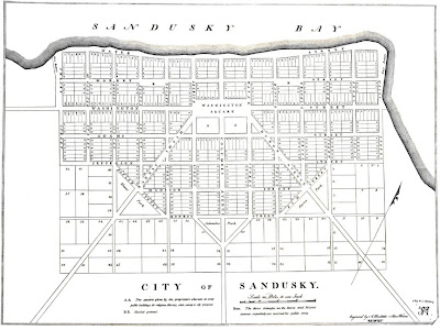
Columbus Avenue was located in the very center of the 1818 Plat Map of Sandusky. Known as the Kilbourne Plat, downtown Sandusky was laid out in the shape of the Masonic emblem.

Local historian James A. Ryan wrote in the January 20, 1932 issue of the Sandusky Star Journal that while Water Street was the location of the very earliest Sandusky businesses, Columbus Avenue saw significant growth in development between 1850 and 1880. W.T. and A.K. West operated a dry goods store on Columbus Avenue before they opened the West House hotel located at the southwest corner of Columbus Avenue and Water Street in 1858.
William A. Graham operated a drug store on the southeast corner of Columbus Avenue and Water Street.
Columbus Avenue continued to be part of the major transportation and business center of the city of Sandusky. Several modes of transportation can be seen at the foot of Columbus Avenue about 1900. (The steamers A. Wehrle, Arrow, and R.B. Hayes are visible in this image.)
Parades held in Sandusky were often routed down Columbus Avenue. A parade held by the Knights of St. John took place in 1910.
Visit the Sandusky Library Archives Research Center to view a variety of books, newspapers, photographs, and other archival resources relating to the history of Sandusky and Erie County.

Tuesday, July 01, 2008

The Map Collection at the Sandusky Library


Visitors to the Sandusky Library Archives Research Center in recent months may have noticed new map cabinets at the far end of the reading room. These cabinets, along with environmental monitoring devices (for temperature, humidity, and water leaks) for the archives storage room, were purchased with funds from a Preservation Assistance Grant from the National Endowment for the Humanities.

Recently we have completed transferring our oversize map and poster collections to these cabinets -- to allow for better storage of these items and to create more storage space for other materials in the storage room. The map collection, which includes early maps of Sandusky and the Sandusky Bay, among others, is available to researchers in the archives. See the Archives Librarian or any Reference Librarian for assistance.